All posts by paula

Mt. Whitney and the Alabama Hills – Lone Pine CA

We were in Lone Pine for Jeff to visit his son Dave who was participating the Rally Races with a group he’s part of.

While there we took a drive one day up to Mt. Whitney as far as you can drive, and then through the Alabama Hills.

Mt. Whitney is the highest point in the continental US at 14,505 feet. You can drive up to just over 8,000 feet then you have to hike. We did not hike! We met a lady at the viewpoint where we stopped who was there to hike up the mountain the next day. Today she said she was just going to walk around the area and then stay at a motel in town to head out really early the next day. She was originally from Turkey and had been in the US for all of her adult life. She was married and had two adult kids but they didn’t like to hike so she had to do it alone. She was very interesting to chat with!

The Alabama Hills consist of very interesting rock formations that run for several miles. We saw a few RVs boondocking amongst the rocks.

Here are pics from Mt. Whitney and the Alabama Hills:

Rally Races in Lone Pine, CA

While in Lone Pine Jeff had the chance to see the Lone Pine Time Trials, a rally race event. His son Dave is a staff member. He’s been trying to see this event for years and finally the timing worked.

A lot of people come here to run and he met a lot of neat people. He hopes to be able to go again, maybe next year!


Here are some pics:

and here are 2 videos:

Video 1

Video 2

Caverns of Sonora, TX

While travelling west towards Vista we stopped at the Caverns of Sonora. They have a small RV Park there which was real convenient! They also have several peacocks on the property and our site looked towards the fence onto a working ranch. One afternoon several cows strolled up to the fence right next to us and Chloe went crazy barking! Once we got her calmed down she watched the cows for quite a while. They, however, showed no interest in her at all.
The caverns are billed as “World Famous” and it’s mostly because it has some very unique features that even other cavern owners and experts agree are truly amazing! These unique features include soda straws that grow in every direction instead of just down, tons and tons of popcorn areas and stalactites that fan out like a fish tail or butterfly wing.
Here are some pics we took:

Annular Eclipse of 2023

We made our way from California to Hondo TX to be there in the path of totality for the annular eclipse on October 14th. We were there…but because of cloudy skies and a camera malfunction, we didn’t get any photos of the eclipse. But we did see it when clouds passed by and the sky cleared a few times.

Oh well! It was still exciting, and we enjoyed being at an Escapees Co-op park where everyone was friendly. They held an after-eclipse party that we attended.

Bodie Ghost Town and Mono Lake

We were heading from Klamath Falls to AZ along Hwy 395 which is on the east side of the Sierra Nevada mountain range.  We stopped for a while in Bridgeport, CA which is close to the Bodie Ghost Town and also Mono Lake.

We visited both places back in 2013 but we wanted to visit again.  Mono Lake looked different because there had been a lot of snow pack and rain this past winter.  The lake was larger than before and a lot of the formations called Tufas were underwater.  Back in 2013 we walked around and between lots of them but couldn’t do that this time without swimming!

Bodie, however, looks the same!  It’s in a state of “arrested decay” meaning they maintain the  buildings but don’t improve anything.  It was pleasant to walk around and see the different buildings, homes, stores, a schoolhouse etc.  We did not take a tour of the mine.  We were able to take Chloe and she was very well behaved and enjoyed it too.  Here are some pics:

Lassen Volcano National Park 2023

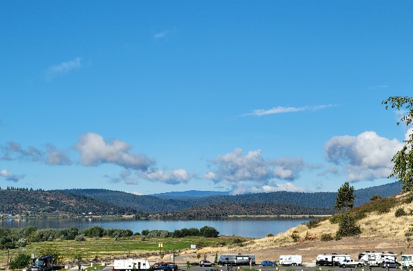
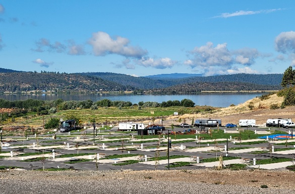
We stayed for a week at an RV Park right on Lake Almanor in the town of Chester.  It’s the largest reservoir in CA and was built and is managed by PG&E, with a hydroelectric plant at the dam.

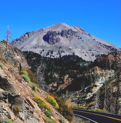
Chester is near the Lassen Volcano National Park.  We spent one day driving in and around the park to see the beautiful area.

Lassen is considered an active volcano.  It has mudpots and steam vents.  One mudpot is right along the road so we got a good picture of it.  It’s sulphuric and boy did it stink!

The volcano erupted in 1914 and then twice in 1915.  Three days after the first 1915 eruption a group of 6 men, including a photographer, traveled up to see the area and were amazed at the huge devastation area.  The photographer got several really great pictures.  They left early that afternoon and it’s a good thing they did because the 2nd eruption happened later that same afternoon!  With the condition of the roads they most likely would have died if they hadn’t left.

There are several beautiful lakes in the park, a couple right along the road.  People can swim and boat (no motorized craft) in the lakes and several lakes have campgrounds right on the lake edges.

In 2021 the Dixie Fire, which is the largest in CA history (to date) started about 40 miles away from the national park and much of the national park burned.  It was interesting to see how in many areas the road through the park is the dividing line between what burned and what didn’t.  The fire came really close to the southern Visitor Center and I included a picture showing how close the fire came. 

The town of Chester didn’t burn but as soon as you leave the town limits you can see a lot of burn areas.  W heard there is a town called Greenville near the southern end of the reservoir that wasn’t so lucky, over 200 homes were destroyed and most of the downtown area.  We drove around Lake Almanor and down to Greenville.  The town of Greenville still shows a lot of scars from the fire with lots of burned out brick buildings and empty lots.  They’re busy repairing and rebuilding the town!

Here are pics of the national park and nearby areas:

Crater Lake 2023

While in Klamath Falls we took a day and drove up to Crater Lake.  We waited for more than a week to get a clear day instead of cloudy, but what we got instead was a smoky day due to fires burning around (but not in) Klamath Falls.

We still had a great time at several overlooks where the lake, the island and the formations at the rim of the lake were visible.  The rim road was not open the whole way around the lake due to road work, so we had to drive one way a little more than half way and then turn around and go back to the main visiters center and then drive the other way for a little more than quarter way and turn around.  It actually worked out good because there are formations that you can only see driving in one direction.  We missed them driving the other direction so if we had been able to circle the rim we would have missed several really cool features of the lake area.

We also took a side drive to a place called Pinnacles where there are many feet of ash that was sculpted by erosion into weird spiky formations.

Even though it was smoky and several pictures just didn’t come out very good. We got several good pictures showing the area.  Here they are:

Lava Beds National Monument

While staying in Klamath Falls we drove down to the Lava Beds Natl Monument.  It’s a really unique place!  There are several volcano domes that erupted over a period of several thousand years.  It also has a very huge lava flow field and dozens of lava tube caves.

One of the volcano domes that erupted created a large crater that you can walk down into a ways.

Some of the caves are open for exploring.  Most people do self-guided tours of the caves and people are required to have a flashlight and hardhat and sometimes knee-pads and gloves in order to tour caves.  One is lighted and has a paved walkway but several are moderate or difficult – the difficult ones you have to crawl a lot.  Not for me!!  We didn’t do any cave tours because we had Chloe with us and didn’t want to leave her in the truck for any length of time.

There was also a cliffside not far from the lava flow area where ancient people drew lots of petroglyphs.  Unfortunately over the decades lots of settlers and modern people have put graffiti on parts of the wall.  There is a fenced off area now protecting the petroglyphs.

Here are pictures we took:

We spent a month relaxing in Crescent City

After leaving Klamath we arrived in Crescent City, CA. We stayed at an RV Park right on the bay. We could continuously hear the foghorn (every 5 seconds!) but it wasn’t loud enough to be annoying. From the RV Park we only had to walk over a small levee and we were on a beach that allowed off-heash dogs. Chloe LOVED it!

We didn’t really go see any sights while here. We just relaxed and enjoyed the cool and often foggy weather while hearing about the horrible heat smothering much of the country.

Here are a couple of pictures, showing the beach on the bay looking both south and north. The bay is real shallow so at low tide there’s a lot more beach than at high tide. In the “looking south” picture you can see Chloe, who was running in the huge area uncovered by the low tide that day.