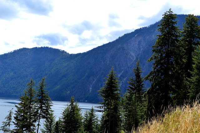
We came to the Rock Mountain National Park to get a feel for what the Rockies are like. This is a very unique park; there is a paved road that goes up and along some of the high part of the Rockies – the highest point on the road is 12,183 feet up!
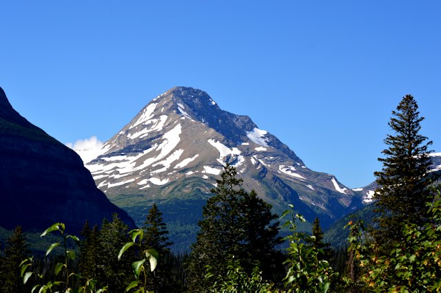
We saw very beautiful scenes of the mountains, several glaciers, alpine tundra above the treeline where nothing else will grow, and several herds of elk! Knowing that the Rocky Mountains were formed by uplift when two tectonic plates came together and one was pushed down and one up, I was surprised to find an area of lava cliffs high in the mountain range that was from a volcano that erupted over 14 million years ago…that’s even before the Rockies were as high as they are today!
The park doesn’t have a ‘loop road’, so we started in Grand Lake where we’re staying, on the west edge of the park, and drove along the road to the east edge where the town of Estes Park is. Then, after lunch we got back on the same road and came back to the west edge. We saw some views coming west that we didn’t notice going east, so it was well worth travelling the same road from both directions!
I have always suffered from altitude sickness and knew I would have problems at these altitudes! I read about a study that said sumiptriptan (migraine medicine) helps with altitude sickness, and I had taken one before we drove up to Pikes Peak (over 14,000 feet!). For this trip I waited to take one and when at 11,000 feet I really started feeling light-headed, a bit queasy and anxious, which are the symptoms of altitude sickness. So, I took a tablet and during the return trip coming west I really noticed that it helped – I was just a little bit light-headed, not at all queasy and not anxious (anxious feeling really manifests when we’re on a tight switchback road with steep drops on my side of the vehicle!). Yeah!
We enjoyed the Rocky Mtn Natl Park so much we decided to drive it again, taking in a couple of different options. We had to drive the same route as the previous trip to get from the west to the east, but then we took a side trip to Bear Lake. It didn’t go nearly as high, and unfortunately it appears this is the most popular part of the park as all the turnouts and parking lots were full, so we couldn’t stop and walk down to the lake to take pictures. They have shuttles from a parking lot a few miles away up to Bear Lake, but we had Laddy with us and he could’t go on the shuttle. Oh well.
Then, for the east-to-west return trip we decided to take a little dirt road – the original Ridge Trail road. It’s one way going up and was literally just wide enough for the truck. The switchbacks were very narrow! It was really good though as we saw some different and incredible views amd glaciers! And, another elk, this one a large buck with either damaged or deformed antlers. He was munching on some grass right next to the road and didn’t even flinch when we pulled up, stopped, and took a few pictures. There were other cars on the road and they all stopped too.
Then, after we rejoined the main road and started going down the switchbacks on the west side of the park I noticed a large glacier across the valley with a bunch of brown dots in it that I hadn’t noticed on the previous trip. “Hey” I said to Jeff, “are those animals in the snow?” We pulled over and got out the binoculars and sure enough, there was a large herd of elk, with many on the grass and many standing around in the snow. Why would they stand in the snow where there’s no grass, when there’s grass just a few feet away? Who knows, but we took a couple of pictures of it.
Interestingly, the part of the mountain range where the elk were standing in the snow is called “Never Summer Mountains”. With large patches of snow year-round, it’s a good name!
Here are pictures we took both days in the Rocky Mountains:
elk with young walking through trees
glacier with a stream running through it
Jeff at the Continental Divide signpost
large glacier with truck parked nearby for scale
lava cliffs with glacier and small lake below
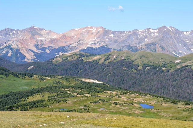
mountain above the tree line in Never Summer Mountains
road winding up to summit at over 12000ft
rock cut – lava at mountain top from eruption over 14million years ago
rock spires seen from the dirt road
The Never Summer Mountains
the original Ridge Trail road – one way dirt road
view of a river from switchback
view of a valley from the switchback
view of mountains with alpine tundra in foreground
young elk relaxing in the grass
elk crossing the road right where all the people and cars are – no fear!
Elk standing in the snow closeup
elk with a damaged antler
elk with nice rack right on roadside