All posts by paula

A drive around Long Lake

While we were staying in Nine Mile Falls which is in the eastern part of Washington, we took a drive through the area. There’s a lake nearby called “Long Lake” that is very pretty.

The lake has a dam at the western end to create the lake and provide electricity for the area. The dam was interesting to me as it isn’t shaped like the usual dam, rounded like an arch to provide the best defense against the massive weight of the water behind it. This one is shaped with a 90-degree corner facing outward instead of inward.

While we were at the dam we met a group of guys all in red shirts that were a maintenance group – during the summer they fight fires when needed and the rest of the year they provide maintenance at several state locations, the dam being one. We spoke to the foreman who told us about the fires they had fought that summer (Washington had several fires along with Oregon, Montana, Idaho and B.C.). He also said they had recently cleaned and upgraded the dam.

Here’s a picture we took of the dam:

Yet another mishap with our axles – what is going on?!?

Yet another mishap with our axles – what is going on?!?

Oh no! About a half-hour after we left the Vancouver area headed east towards the windy mountainous road that is Hwy 3 a truck pulled alongside us and pointed at our rig. We knew that meant something was wrong so we pulled to the shoulder and were horrified to see that a third wheel was smoking badly. That meant we had another bearing that was failing and would lose our wheel shortly. It had already happened twice this year!!

So we sat in the truck and looked for a repair shop in the nearby town of Langley. We are once again SO LUCKY that this happened near a large town instead of up in the mountains where we were headed!

We found a place that specializes in springs and axles and called them to say what had happened and we were on our way to them. We limped down the highway shoulder and off at the next exit and had to go about 10 more miles to get to the repair shop.

We didn’t bother calling a tow truck because the previous two times the tow truck said there’s nothing they can do except escort us limping to a repair place. So, we limped on our own this time. About half-way to the repair shop, on a suburban road, the wheel fell off and we had to stop so Jeff could go retrieve it. We held up traffic a bit but there wasn’t much so they were able to get past us.

With wheel retrieved we limped the rest of the way at about 20 mph and finally pulled into the repair shop. Gerry, the owner, said they weren’t real busy and he could get right on it and we should have it back the next day.

However, shortly after we left the trailer with him and went in search of a motel he called. He was very unhappy with the way the previous repair shop had ‘fixed’ the rear axle (this time was the front axle) as they had lengthened it with a welded ‘sleeve’. He said this was not good as the axle couldn’t flex like it should. We headed back to the shop to get a better explanation and ended up replacing both axles. He did replace both with higher rated axles, the originals were 5200 pounds each. The rear axle was raised to a 6000 pound. Now we have two 7000 pound axles!

So, we got a cheap motel for the day, hung around and got the trailer back late the next day. We stayed at an RV park in Langley and headed out the next morning. So, our trip was delayed by 2 days but it could have been so much worse!

I didn’t take pictures this time, but the two previous stories about our wheel problems, here and here, include pictures.


Driving the Crow’s Nest Highway in Canada (Hwy 3)

We crossed into Canada at the Roosville station, north of the Kalispell MT area. Our original plan was to enter Canada here close to the Banff, Yoho and Glacier National Parks of Canada, then travel to Vancouver and cross back into the US at Washington.

But, shortly before we crossed the border we learned that it’s not hard to bring handguns into Canada, it’s almost impossible. Citizens in Canada cannot carry guns, and the process to bring a gun into Canada takes at least 3 months, has to be approved by a provincial official and may still be denied if you don’t have a good reason. So, we decided to put our guns into a mini-storage unit in Kalispell while we were in Canada.

This meant that we had to travel back to Kalispell to get them. So, we decided that from Vancouver we would travel east on the Canadian “Crow’s Nest Highway”, Hwy 3, which runs very close to the border and is very scenic.

Our trip along Hwy 3 took 2 days, partly because we don’t travel for over about 5 hours in a day and partly because it was a windy mountain road so for long parts of it we were going much slower than 100 kmp (60 mph).

It was a beautiful drive. Very scenic, first we went through forested areas, up and down the mountains. Then we entered a beautiful valley that was like a fruitbasket. Tons of apples, peaches, plums, pumpkins, fruit stands, fields of corn and wheat. Our first night was in Osoyoos which is near the Columbia River that runs through this valley. It was a beautiful RV park, lots of trees, right on the river! I wished we could stay a week!

The next morning we drove to Crestin where we planned to cross the border the third morning. We got up into some summits that were about 7,000 ft and noticed they had recently had snow. There was some along the road and all through the mountaintops nearby. Beautiful, but cold! I think it got to the low 50s along that drive, mostly was in the 40s. In September, brrr!

The third morning we crossed into the US and headed back to Kalispell. The night before we crossed I had a nightmare that when we crossed the border they wouldn’t let us in unless we swore loyalty to Trump. Argggghhhhh! NNNNNNNNNNooooooooooooo!

Luckily it was just a nightmare and we crossed without incident!

I tried to take a few pictures with my phone but in a moving vehicle they didn’t turn out. Here’s a picture of the snow:

Our visit to Vancouver

We’re staying in Surrey while visiting Vancouver, and we drove around Surrey to run errands and drove through Vancouver to see the city.

As we drove through the downtown section of Vancouver I noticed first the vast number of people walking in the city. Large numbers of people at every street corner and walking on every street. I mean large, much more than I ever saw in San Diego, and even more than I’ve seen in downtown New York. And, in the bad part of town there were so many homeless people…dozens of them on every block! I even looked down one alley and saw probably 20 or more people sitting down or walking around. I’m sure I even saw a drug deal in just the second or two that I could see down the alleyway. I’ve seen segments on Canadian TV news shows about the fact that the city is unaffordable for many people and that it has caused a huge homeless problem. Yep, I saw that!

This is a very densely populated city! Lots and lots of highrise apartment buildings, both in the downtown area and in a couple of the suburbs. Burnaby, a close-in suburb, had over 15 buildings that were at least 20 stories high.

Another thing that struck me is the ethnic diversity. As we drove around we saw very few black and hispanic people and lots and lots of Asian people. Many, if not most, of the store signs both downtown and in Surrey were in both English and some Asian language, probably Chinese. We also saw a lot of Sihk men wearing the turbans, both walking and driving around. In one neighborhood of Surrey we saw so many that I looked up ethic demographics of Vancouver. Less than 1% black. Less than 1% hispanic. About 25% Asian and about 11% ‘South Asian’ which includes the Sikh people. Only 52% are Caucasian. The article I read even mentioned the exact neighborhood we were driving through, saying in that particular neighborhood there was the largest concentration of Sikh people, at about 76%!

Vancouver is a very pretty city, with the mountains to the north and east and several harbors and inlets. It’s actually kind of isolated on the coast because just a bit further north along the coast are a mountain range that isolates all other coast communities except by boat. The Trans-Canada Highway is the only way to get east, and the Al-Can (Alaska-Canada) Highway follows the Trans-Canada Highway for several miles east before it turns north.

The weather is about what we expected for September, not too warm during the day but not too cold yet at night.

We are enjoying our stay here in the Vancouver area!

We took a harbor cruise around the Vancouver Harbor

One of the things I wanted to do in Vancouver was take the ferry over to Vancouver Island and drive around there to see the sights. But, the cost of going over on the ferry for a vehicle and 2 people was over $50 – one way! Yipes! That was too much money, I felt.

So, instead of that, we took a sightseeing cruise around the Vancouver harbor. It was real interesting, and we learned quite a biabout Vancouver and Canada. The harbor is really large and is home to a very large drydock for repairing ships. There are several Canadian Navy ships docked there, there is a container ship area where huge container ships from the Asian ports get loaded and unloaded, and there is a seaplane dock as well as lots and lots of private ships, boats and a rowing club.

Vancouver also has a very large park in the midst of downtown and right along the harbor that is larger than Central Park in New York. The tour guide had a fun story about the Vancouver park – it had no squirrels, and when New York heard about that they shipped 2 pairs of gray squirrels to the city of Vancouver so their park could have squirrels. Well, now there are apparently way too many since there are no predators, and the tour guide said if you visit the park you’ll see that all the squirrels still have their New York accent. He also said if you visit the park and a squirrel throws an acorn at you, thank the city of New York. LOL

Back during the depression the Canadian government had lots of projects to keep men employed, just like the U.S. did. One project was to build a seawell along the downtown park where it was on the coast, to keep erosion down and provide a safe place for people to walk, jog or bike around the perimeter of the park. Also during that time, a wealthy family, the Guinness family of the beer fame, privately funded building a bridge from the downtown park across the mouth of the harbor to the north Vancover area. For several years there was a quarter toll to cross the bridge until the family was repaid, and since then it’s been free to cross and maintained by the government. It is a problem now though, since several large cruise ships use Vancouver as a base of operation and the largest ships cannot get under the bridge. So, the city is debating whether they need to replace the bridge in order to get the largest cruise ships into the harbor.

This busy harbor is home to lots of harbor seals and we saw several. We also saw several jellyfish swimming around in the harbor.

The day was beautiful and warm for our harbor cruise and we had a great time. Here are some pictures:


Hell’s Gate Gorge on the Frazer River

Along the Frazer River in central B.C. there’s a narrow gorge called Hell’s Gate. It was named by the man who first navigated it, Simon Frazer, in 1808. He and his group of men were canoing down the river and tried unsuccessfully to canoe through the gorge. It was too wild and deep. He said “Surely these are the gates of hell and no man should attempt to cross”.

Well, he did get past it by climbing along the sides, in some places by hanging a shelf of wood by ropes so they could pass the places with no footholds. He finished navigating and mapping the river.

It was still a most difficult part of the river, and caused many deaths and hardships. One man decided he could come upriver in a steamboat and get through the gorge in order to bring supplies to folks upriver. He tried several times and finally had to have Chinese workers along the steep walls of the gorge basically drag the boat through the gorge. If a worker lost their foothold and let go they fell into the river and drowned. He did that several times.

In the early 1900s a road was carved into the mountains past the gorge, and in the 1940s a railway line was built. While dynamiting the hillside above the gorge a large quantity of rocks fell into the river and the next year it was discovered that it prevented the salmon from getting past the gorge on their way upstream to spawn. This was a catastrophe! For several years, people who lived in the area would catch salmons in nets, transport them through the gorge and release them above the rockfall area. This helped but was not enough. So, the government devised a bypass for the salmon – sort of like a set of locks through the Panama Canal! The salmon swim into a narrow opening in a concrete bunker and are able to swim through it to an opening above the rockfall. It worked! The salmon have not recovered from their pre-rockfall numbers and never will, they now can swim upstream in enough numbers to preserve the species that instinctively swim up this river to lay their eggs.

Today the gorge is travelled by the TransCanada Highway and two railway lines, one on each side of the river. There is a tram that takes visitors from the TransCanada Highway down to the gorge for a visitor center with a restaurant and some hiking trails. People can hike down to the river and cross the suspension bridge to get to the visitor center as well – but we chose to ride the tram!

Here are pictures:

Lac Du Bois Protected Grasslands and our adventurous drive

While staying near Kamloops for a few days we visited the Lac Du Bois protected grasslands. This area, in central B.C. about halfway between the coast and the Canadian Rockies, is considered a semi-arid region, some call it a desert.

It does resemble southern California! Brown grass, sage and small scrub plants, gravelly soil. We were told it hadn’t rained for a few months, but it rained the day we arrived and we got soaked setting up.

The maps showed several roads running through the protected grasslands area. Although they were listed as dirt roads we hoped they wouldn’t be too rough and we wanted to see the area. The website for the grasslands area indicated that the area got quite a few visitors.

We planned to drive to the west part of the protected area and take a dirt road up into the hills and drive east to connect to the main road, Lac Du Bois Rd, and take that north. Then, we would hook up to another road going east that would take us to the major river in the area and back down into the city.

Well, on the western edge of the area we found the road listed as Red Rock Rd, but it was gated off and was a mountain biking or hiking road only. Oh oh!

So we backtracked and found the main road, Lac Du Bois Rd, and headed north on that. We went through some beautiful countryside and we were both reminded again of the southern Ca. area – maybe up around Julian in August or September.

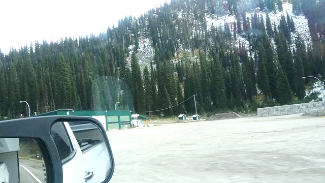
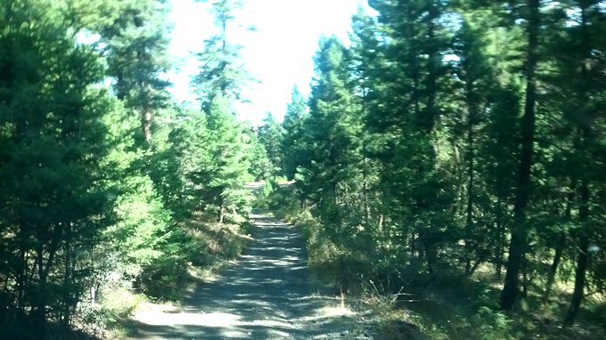
We passed a few cars and trucks travelling on the road. We found the road that we planned to take heading east to the river, and turned. There were signs indicating that there was a camp area for local schoolkids nearby. The area quickly turned from open grasslands to forest with pines and other large trees everywhere. Very pretty!

Well, we drove and drove. The level dirt road got narrower and bumpier. After a while we started hitting potholes filled with water so we couldn’t see how deep they were. Some were very deep! I bounced up out of my seat several times and poor Laddy was just trying to hunker down in the back seat. We had to stop once as several cows were laying in the road; they did get up and move out of the way.

We came to an area with some slight switchbacks so we felt we were getting closer to the river. Down and around we went, bouncing around and scraping the sides of the truck on branches.

Then, we came to a washed out streambed. There had been a bridge at one time and it was gone. We looked around and found a place where someone had obviously gone through the stream but it looked like an ATV or maybe a dirt bike or mountain bike tracks. Not a large vehicle!

Dang, after all that we had to turn around and go back through all the potholes. But, we did make it back to the Lac Du Bois dirt road which by that time felt like a freeway! Backtracking all the way, we made it back to the city of Kamloops and stopped for lunch as the trip was a lot longer than we thought it would be.

Later I re-read the website material and still couldn’t see any indication that the roads were closed to vehicles/unsafe/washed out/whatever. Dang!

Here are a few pictures of the grasslands and the narrow road we drove down:
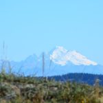
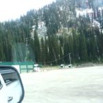
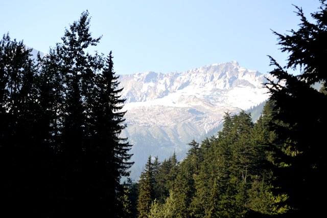
The Columbia Icefield – it’s huge but receding

One of the things we wanted to see while in the Canadian Rockies was the Columbia Icefield. It’s one of the largest icefields outside the Arctic Circle. It took over 3 hours to drive to it but it was definitely worth it. Visitors can park near the visitor center and hike out to the edge of the icefield – about 2/3 of a mile. Boy, it was COLD as you got close to the ice, I’m glad I had a jacket and hiking boots on.

It was very interesting and also sad to see how far the icefield has retreated though – 20 years ago the parking lot where we parked was right at the edge of the icefield, and 100 years ago it covered where the visitor center and highway are now.

We didn’t see any wildlife near the icefield or on the drive up or back. I’m told there’s lots of wildlife though. It’s possible the smokiness in the area has caused the animals to stay away from the roads, I don’t know.

It was very smoky in Golden where we stayed, and was smoky through the Yoho National Park. But, as we got closer to the icefield it wasn’t as bad. I think it’s because the smoke couldn’t get over the higher mountains in that part of the Canadian Rockies.

Beautiful area! Here are some pictures:

Canada has a Glacier National Park too!

Golden, B.C., where we stayed for a week, is just a short drive from Glacier National Park of Canada, so we took a ride there to see the mountains and glaciers. It was quite smoky due to all the fires burning in B.C. this summer, so visibility was not real good. Also, the road through the national park isn’t intended to allow visitors to see the best views and glaciers – it’s the TransCanada Parkway, Hwy 1, so it’s more intended to get people through the area.

But, we still enjoyed the trip and the scenery and glaciers. There were several that we could see from the road. There were also several “snow sheds” that are tunnels through an area of steep mountainside that, during an avalanche or heavy snowfall, would bury the road completely. The “snow sheds” allow travel with just a little bit of clearing away snow or landslide at either end. They are also for safety during an avalanche; we saw signs that said in case of an avalanche try to get to a snow shed.

Here are some pictures we took: